Introduction
India’s terrain diversity allows it to function as a controlled geographic substitute for politically sensitive or logistically unstable regions. Instead of exposing cast, crew, and capital to volatile border conditions, productions increasingly assess elevation systems, snow bands, and rock morphology within India to recreate narratives set in Pakistan, Afghanistan, or Western China. The decision is driven by landscape physics rather than political alignment. Terrain is evaluated through slope geometry, atmospheric clarity, horizon depth, and seasonal light behavior.
High-altitude plateaus in Ladakh, alpine corridors in Himachal Pradesh, and transitional mountain belts across northern India offer visual continuity that aligns with cross-border storytelling without importing geopolitical instability. This geographic logic supports the broader structural thinking explained in using India as a stand-in for Pakistan Afghanistan and China, where substitution is treated as a calibrated environmental system rather than a superficial backdrop.
India compresses multiple mountain ecosystems within reachable corridors. Productions can transition between cold desert altitude, forested alpine slopes, and exposed ridgelines without restarting logistics. Geography becomes modular, predictable, and lens-ready.
Terrain Compression & Modular Scheduling
India’s terrain compression creates a scheduling advantage rarely available across politically sensitive regions. Within a limited aviation radius, productions can transition from cold desert altitude to alpine forest, and from alpine forest to semi-arid plains without resetting logistical command structures. This geographic proximity reduces relocation downtime, stabilizes crew movement, and preserves narrative continuity across terrain shifts that would otherwise require cross-border coordination.
Because these environments sit within a single national framework, narrative transitions can be executed within one structured shooting window. A sequence requiring exposed ridgelines, followed by fortified desert architecture, and concluding in dense urban compression can unfold within a contained production calendar. Terrain becomes an interchangeable module rather than a jurisdictional risk, strengthening visual authenticity while maintaining operational predictability.

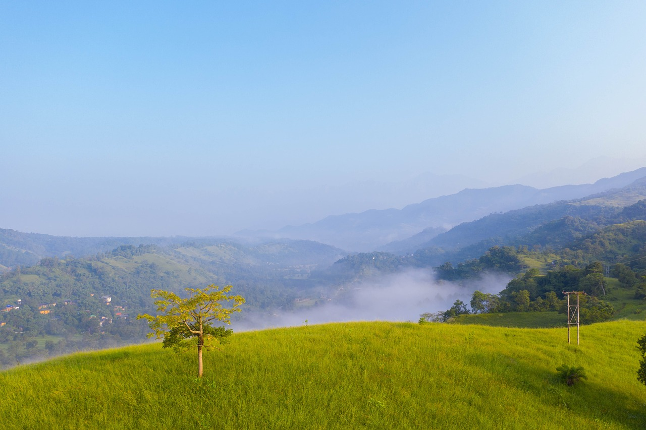
High-Altitude & Mountain Terrain Matching
High-altitude terrain carries a specific visual authority. It signals isolation, conflict intensity, border tension, and environmental extremity. Replicating this convincingly requires more than mountains. It requires elevation behavior—how light scatters, how air density sharpens edges, and how terrain silhouettes interact with the sky.
Elevation Physics
Elevation alters visual perception in measurable ways. Above 2,500 meters, reduced atmospheric density increases contrast and deepens sky tone. Blue saturation intensifies, shadows sharpen, and distant ridgelines appear cleaner. These atmospheric characteristics are critical when replicating Afghan highlands or northern Pakistani border belts.
Ladakh’s cold desert plateau reproduces this physics with precision. Its sparse vegetation, stratified rock faces, and expansive horizontal valleys allow unobstructed framing. Ridgelines extend without urban interruption, preserving long silhouettes suitable for wide establishing shots. The terrain supports deep focus cinematography because particulate interference is minimal at altitude. This clarity reinforces realism.
Access coordination through line producer in Leh Ladakh filming permits ensures that productions can operate within these exposed environments while preserving the visual integrity of ridgeline geometry. The landscape’s value lies not only in appearance but in spatial continuity—mountain forms that read consistently across multiple camera positions.
Himachal Pradesh offers a complementary elevation system. Instead of cold desert exposure, it introduces forest-dense slopes, terraced gradients, and valley compression. Through line production Himachal Pradesh nearby locations, productions can access alpine forests that resemble transitional border zones where terrain shifts from arid to vegetative. This allows narrative layering without breaking altitude logic.
Elevation physics also influences sound behavior and wind movement. Thinner air produces sharper wind signatures and reduced ambient echo, which enhances realism in conflict-driven scenes. Dust displacement patterns at altitude differ from lowland environments, producing lighter, more dispersed plumes that align with Central Asian visual references.
Snow & Seasonal Light
Snow coverage transforms terrain behavior. It increases reflectivity, reduces color noise, and amplifies shadow definition. In Himalayan corridors, winter months create high-albedo surfaces that replicate the stark brightness associated with mountainous regions in Afghanistan and Western China. Snow absorbs and reflects light unevenly, producing tonal contrast that strengthens depth perception on camera.
Seasonal timing determines visual authenticity. Early winter generates partial snow cover ideal for transitional war sequences where terrain appears unstable and rugged. Peak winter delivers uninterrupted white plains that eliminate vegetation cues, simplifying the frame and heightening dramatic isolation. Late winter and early spring introduce melt channels that carve organic lines into slopes, mimicking thaw cycles seen in northern conflict zones.
Solar angle further intensifies authenticity. At altitude, sunrise and sunset extend laterally across ridgelines, casting elongated shadows that sculpt terrain contours. This side-lighting reveals rock texture and elevation variance in ways lowland lighting cannot replicate. Golden-hour windows at height produce high-contrast silhouettes ideal for tension-heavy sequences.
Wind interaction with snow also influences realism. Powder displacement at elevation creates fine particulate trails rather than heavy drifts, aligning visually with footage from highland regions beyond India’s borders. When these physical behaviors—light scatter, snow reflectivity, ridge continuity, and wind pattern—are combined, the result is a terrain match grounded in environmental science rather than aesthetic approximation.
Integrated together, Ladakh’s cold desert altitude and Himachal’s alpine gradients create a mountain substitution matrix. Productions can move between exposed plateaus and forested ridges without abandoning elevation credibility. High-altitude replication in India is therefore not scenic coincidence. It is the controlled application of terrain physics, seasonal timing, and atmospheric precision to achieve visual continuity without geopolitical exposure.
High-Altitude Logistics & Continuity Behavior
Filming at elevation also introduces logistical calibration that strengthens realism rather than weakening it. Battery performance shifts in colder, thinner air. Equipment stabilization requires controlled rigging against high-altitude wind shear. Crew movement must adapt to slope gradients and oxygen variation. These physical constraints influence pacing, blocking, and camera setup, producing subtle performance realism that cannot be replicated artificially at lower altitudes.
Equally important is terrain continuity between Ladakh’s cold desert and Himachal’s alpine density. Productions can transition from exposed rock plateaus to forest-lined ridges without disrupting altitude credibility. This flexibility allows narrative arcs that move from barren confrontation zones to concealed mountain settlements while preserving consistent atmospheric behavior. High-altitude replication in India therefore operates as an adaptable system rather than a single scenic reference.

Desert & Arid Geography Substitution
Arid terrain is one of the most demanded visual substitutes when replicating Pakistan’s Sindh belt, parts of Balochistan, southern Afghanistan, or transitional desert corridors associated with Central Asian narratives. However, desert replication is not about “sand.” It is about dune geometry, surface texture, wind behavior, and horizon control. India’s western desert systems, particularly across Rajasthan, provide a structured environment where arid landscapes can be framed without geopolitical instability or cross-border exposure.
The Thar Desert offers wide sand spreads, transitional scrub belts, fortified desert towns, and eroded sandstone structures within relatively short movement windows. This density of variation allows productions to layer desert realism without abandoning continuity. Instead of relocating across international jurisdictions to capture dune fields, salt flats, and stone settlements separately, these visual components can be integrated within a single operational corridor.
Dune Morphology
Dune morphology determines how convincingly a desert substitutes another region. Not all dunes behave the same. Crescent-shaped barchan dunes suggest wind-driven movement and minimal vegetation. Linear dunes indicate directional wind stability. Irregular sand mounds imply seasonal disruption. Rajasthan’s dune fields, particularly near Jaisalmer, display barchan formations and rolling wave-like sand ridges that mirror the desert physics associated with parts of Pakistan and Afghanistan.
The spacing between dunes matters. In many conflict-driven narratives, the camera requires uninterrupted horizon lines to communicate isolation. Jaisalmer’s outer belts provide long sand corridors without urban intrusion, allowing wide-angle framing and convoy movement sequences that feel geographically authentic. The absence of dense vegetation enhances realism, especially for mid-day scenes where heat shimmer and mirage distortion are required.

For a comparative understanding of how Rajasthan’s desert systems align visually with North African references, see filming Rajasthan vs Morocco comparison. The similarity lies not only in sand color but in dune continuity, fort architecture, and open-sky framing capacity.
Coordination through line producer Jaisalmer enables access to dune belts that remain visually uncontaminated by modern elements. Controlled entry ensures that horizon lines remain clean and that vehicle tracks or staging rigs can be managed without breaking desert illusion. Dune shape consistency across camera angles preserves spatial credibility, which is essential for sustained desert sequences.
Sand Tone & Wind Pattern
Sand color and particulate behavior influence how a desert reads on camera. Rajasthan’s sand tones range from pale beige to deep golden hues, depending on mineral composition and time of day. Under harsh mid-day sun, the surface reflects high-intensity light, producing the stark exposure associated with arid conflict zones. During early morning or late afternoon, the sand absorbs warmth and shifts toward amber gradients, enhancing cinematic contrast.
Wind pattern is equally critical. Fine-grain sand produces lighter displacement under moving vehicles, generating thin dust trails rather than dense clouds. This aligns visually with many Afghan and Pakistani desert references where particulate density is lower than in clay-heavy desert systems. Wind-carved ridges create repetitive ripple textures that hold detail under close-up framing, strengthening realism.
Temperature gradients further support substitution. High heat produces visible atmospheric distortion at ground level. The resulting heat haze softens distant objects and compresses depth perception, a hallmark of desert cinematography. Rajasthan’s summer cycles naturally generate this effect, reducing reliance on artificial post-production enhancement.
Architectural overlays enhance authenticity. Sandstone forts, mud-walled compounds, and narrow desert town streets provide built elements that align with border-region storytelling. These structures weather naturally, carrying erosion marks and tonal variation consistent with arid climates beyond India’s borders.
Integrated together, dune morphology, sand tone variation, wind behavior, and heat shimmer create a controlled desert matrix. The terrain does not merely resemble other arid regions; it behaves similarly under lens conditions. By calibrating camera placement to dune curvature, wind direction, and solar angle, productions achieve sustained desert realism without stepping into unstable territories. Arid substitution in India is therefore grounded in environmental accuracy rather than visual approximation, reinforcing continuity while maintaining geographic control.

Solar Trajectory & Desert Transition Control
Desert cinematography also depends on solar trajectory planning. The angle of the sun across dune ridges determines shadow length and surface contrast. Early morning shoots accentuate ripple texture, while mid-day light flattens form into stark exposure fields ideal for conflict intensity. Late afternoon framing restores contour depth, enhancing movement across dune crests. By aligning shooting windows with solar position, productions preserve arid authenticity without digital correction.
Transition capability further strengthens desert substitution. Rajasthan allows movement from open dune expanses into sandstone fortifications and desert town streets within short travel corridors. This continuity supports narrative shifts from isolated convoy sequences to fortified settlement interiors without altering climatic tone. Heat shimmer, dust displacement, and architectural erosion remain consistent across frames, reinforcing environmental coherence while maintaining geographic control.
Urban Morphology & Density Translation
Urban substitution depends less on altitude or sand spread and more on structural layering. Density, facade age, street compression, overhead wiring, signage control, and skyline interruption determine whether a city can convincingly replicate another geopolitical setting. India’s major metros offer controlled morphological variation: colonial districts, post-industrial zones, congested commercial arteries, and partially obscured skylines that can be reframed without structural demolition. The objective is not to duplicate a foreign city exactly. It is to translate its spatial rhythm under controlled geography.
When replicating urban environments associated with Pakistan, Afghanistan, or older Chinese districts, filmmakers assess building height ratios, balcony projection depth, street width-to-height proportion, and façade erosion texture. Cities such as Mumbai and Delhi provide districts where colonial overlays, dense residential clusters, and institutional architecture coexist within manageable corridors. These zones allow productions to isolate visual cues while suppressing modern identifiers.

Colonial Overlay Adaptation
Colonial-era architecture forms one of the most flexible substitution tools within India’s urban fabric. Arched verandas, sandstone or stucco façades, wooden shutters, iron balconies, and narrow lane structures create a neutral base that can be culturally redirected through production design. These districts function as adaptable canvases rather than fixed identities.
In Mumbai, certain neighborhoods retain port-era building typologies that align with administrative or trade-district aesthetics found across South Asia. Through strategic signage replacement, fabric aging, and prop integration, streets can shift visual allegiance without altering structural integrity. The transformation logic is explored in Mumbai as a stand-in or cheat location for global film shoots, where urban layering allows location compression without visible geographic contradiction.
Facade aging techniques—dust layering, color desaturation, temporary balcony modifications, and cloth draping—support believable substitution. Street furniture such as lamp posts, guardrails, and public signage can be masked or replaced to neutralize obvious national identifiers. When executed with discipline, colonial overlays function as visual translators, enabling the same street to resemble Karachi, Kabul, or an older Western Chinese trading quarter depending on framing and art direction.
Delhi introduces administrative gravitas. Government-era buildings, broad ceremonial avenues, and older market districts allow urban sequences that require institutional or bureaucratic backdrops. Permitting pathways and street access logistics are detailed in filming in Delhi navigating administrative and permissions, but from a visual standpoint, Delhi’s layered density provides flexible framing opportunities. Narrow bazaars can double as high-intensity border markets, while colonial boulevards can be reframed as regional administrative centers.

Skyline Masking Strategy
Skyline control determines urban credibility. Modern glass towers, satellite dishes, and telecom masts can disrupt period realism if not managed carefully. Effective skyline masking relies on camera angle discipline, foreground compression, and environmental occlusion.
Low-angle framing reduces visible high-rise intrusion. Shooting from interior courtyards, alleyways, or market clusters narrows the visible sky band and minimizes contemporary contamination. Temporary build-outs—fabric awnings, overhead wiring clusters, scaffolding—can create depth layers that obscure distant towers. In dense urban zones, rooftop extensions and partial set builds further control horizon lines.
Vegetation also plays a masking role. Tree canopies positioned strategically along streets break vertical sightlines. Dust haze, practical smoke, and shallow depth of field techniques soften distant modern architecture. By narrowing focal planes, filmmakers isolate mid-ground detail while blurring skyline inconsistencies.
Street-level density strengthens substitution. Overlapping pedestrian flow, parked vehicles with region-neutral modification, and layered market stalls compress space visually. This compression reduces the need for extensive digital cleanup because the frame becomes saturated with foreground detail.
Integrated together, colonial overlays and skyline masking create an urban substitution matrix. Mumbai’s port districts, Delhi’s administrative belts, and market-dense neighborhoods offer multiple density typologies within reachable corridors. Productions can transition from narrow trade alleys to institutional courtyards without geographic rupture.
Urban morphology in India is therefore not static. It is modular. Building facades, signage layers, street compression, and skyline management operate as adjustable variables. By manipulating these variables, filmmakers translate one geopolitical environment into another while retaining full operational control over location access and scheduling.

Density Layering & Urban Rhythm Engineering
Urban realism is strengthened through density layering. Rooftop water tanks, overhead electrical grids, improvised extensions, and fabric awnings introduce vertical texture that masks contemporary intrusions. Controlled clutter—stacked goods, signage overlays, street-side stalls—compresses spatial perception and reduces visible skyline exposure. This layered density allows filmmakers to reassign cultural identity without structural modification.
Crowd rhythm engineering further reinforces substitution. Pedestrian flow can be calibrated to reflect market intensity or institutional restraint. Vehicle selection, license plate neutralization, and region-agnostic paint schemes help suppress identifiable markers. When layered carefully, these micro-adjustments create controlled chaos that reads as organic rather than staged. Urban substitution becomes a choreography of density rather than a reconstruction of architecture.
Conclusion — Visual Continuity Through Controlled Geography
India’s terrain diversity extends beyond mountains and deserts into adaptable urban systems. High-altitude plateaus replicate border tension, desert corridors mirror arid conflict zones, and colonial-era districts support dense urban substitution. Together, these environments form a geographically compressed matrix capable of sustaining multi-location narratives without crossing unstable borders.
Visual authenticity emerges from environmental behavior—how snow reflects light, how dunes shape horizon lines, how facades age under dust, and how skylines are masked through framing discipline. By focusing on terrain physics and urban morphology rather than geopolitical alignment, productions achieve continuity without importing instability.
This geographic logic aligns with the structured framework outlined in using India as a stand-in for Pakistan Afghanistan and China, where substitution is treated as a controlled system rather than a reactive workaround. The emphasis remains environmental, not administrative. Landscape diversity, density variation, and modular city textures enable precise replication while preserving production security.
Environmental Behavior & Modular Continuity
Across mountain, desert, and urban environments, the unifying factor is behavioral accuracy. Elevation alters light and shadow. Dune geometry shapes horizon rhythm. Street compression influences spatial tension. When these environmental behaviors are aligned deliberately, visual continuity becomes sustainable across narrative transitions. The terrain does not simply resemble another region; it performs like it under lens conditions.
India’s substitution strength therefore lies in modular continuity. Mountain physics, arid morphology, and urban density operate as interchangeable components within a contained geographic system. This controlled versatility allows productions to construct complex geopolitical narratives while maintaining environmental coherence and operational stability.
India’s value in this context is concentration. Multiple terrain types coexist within manageable travel windows, allowing seamless narrative transitions under predictable scheduling. Visual realism does not require exposure to volatile regions. It requires calibrated geography, disciplined framing, and controlled access.
When mountains, deserts, and urban density operate as interchangeable modules, substitution becomes intentional rather than improvised. India offers that modular stability—terrain diversity aligned with visual continuity, delivered without geopolitical risk.
